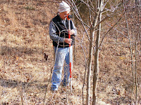
A week ago, four days before the big snow storm, we had a surveyor and his helper come to the property to survey the hoped-for building site and the area surrounding it. The final product will be a contour map of Greene View Springs with more detail in the area we walked. The rest of the property will also be shown using data from aerial photos.
The most important tool of a surveyor is called a "total station," named as such because it incorporates both a distance meter for measuring distances and a "theodolite" for measuring angles. Here Andy has set up his station on the hill north of the pond looking back toward our hoped for home site.


It sends a beam of infrared light toward a prism, shown here supported by an extendable pole held by the surveyor, Eric. The light reflects off the prism directly back to the total station, and, by measuring the time it takes to return, the station calculates the distance, direction and vertical angle between the two.


The information from the total station is recorded in a data collector for later downloading into a computer in the office.
Eric also directed me as we tried to get "shots" at representative spots on the property. I'm not running in the first picture; I'm tripping over one of our %&#$! grape vines! The second picture shows the prism a little better. The last picture shows just a few of the many large trees we marked so they would be shot and shown on the topographic map, our final product.


And while we were having fun thrashing through the woods, Sandy was working so hard she didn't need her jacket, cutting rose bushes I had cut off earlier in the week into small pieces so they can be more easily removed when the weather allows.

Behind that mass of brush is the mouth of our small spring. If the house will fit close enough we'll be able to see the spring from the house's west side.


No comments:
Post a Comment